1.3. Urban Site Analysis - Regional and Local Context
2.1. Opportunities Mapping
2.2. Design Principles
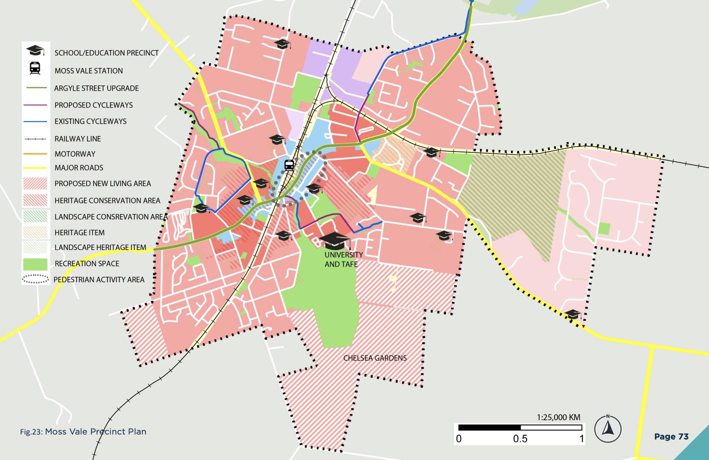
3.1. Precinct Location
3.2. Precinct Plan Options
3.3. Prefered Precinct Plan
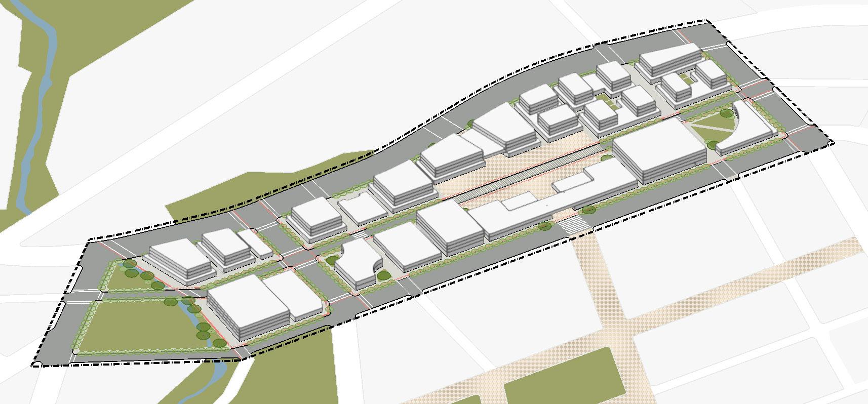
4.1. Illustrative Master Plan
4.2. Public Domain Structure Plan
4.3. Blocks and Built Form Plan
4.4. Proposed LEP Mapping
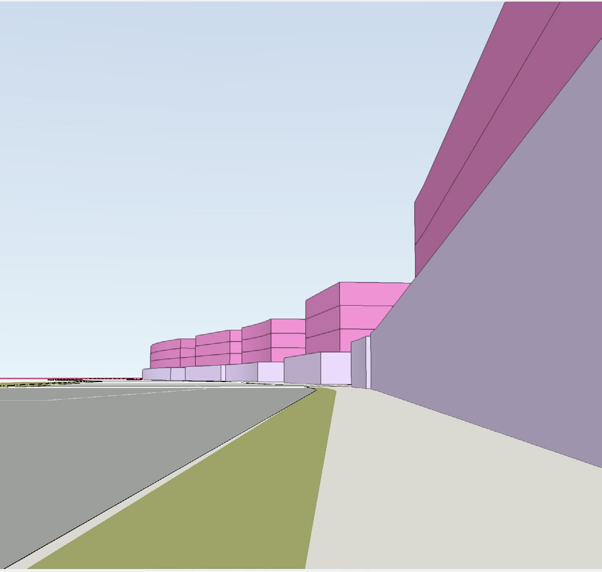
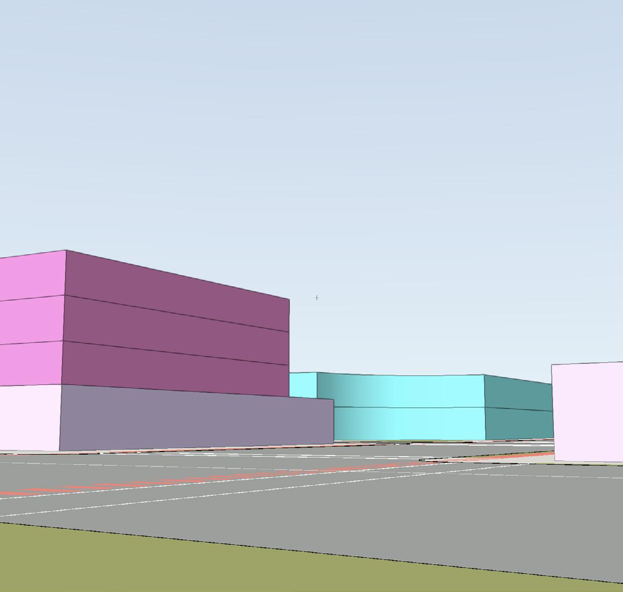
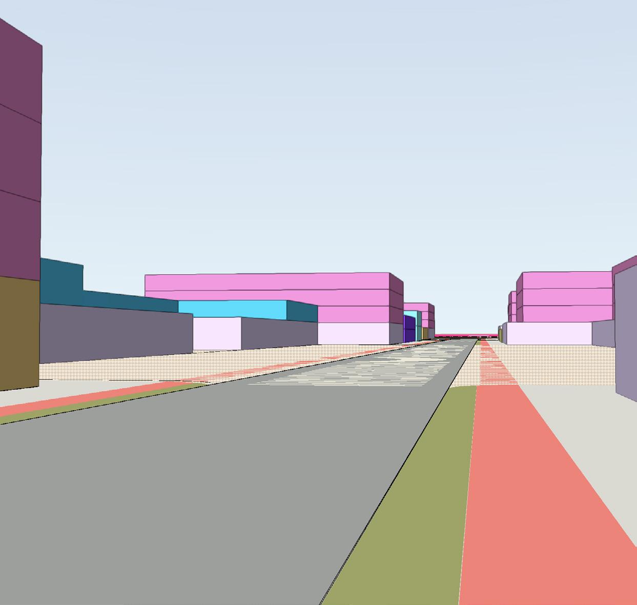
4.5. 3D Views
4.6. Yields
PLAN4002 | 2022 ELLA YALE | z5259987
Claire Waddington, Ella Yale, Kuzivakwashe Jaravani, and Tak Ko Yung
1.1. Executive Summary
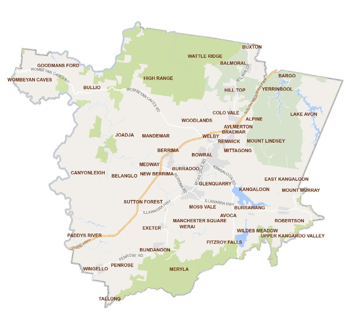
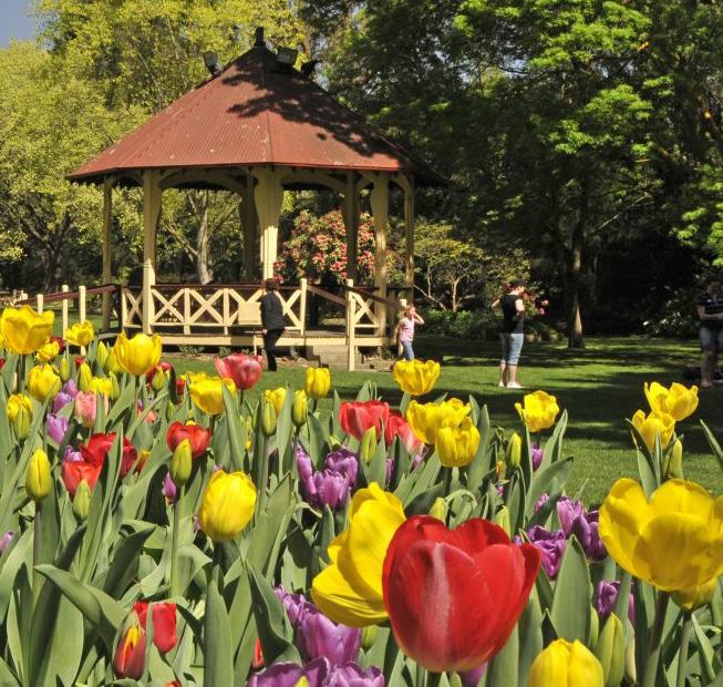
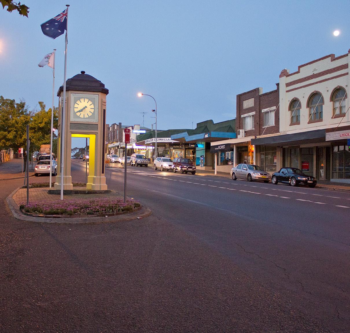
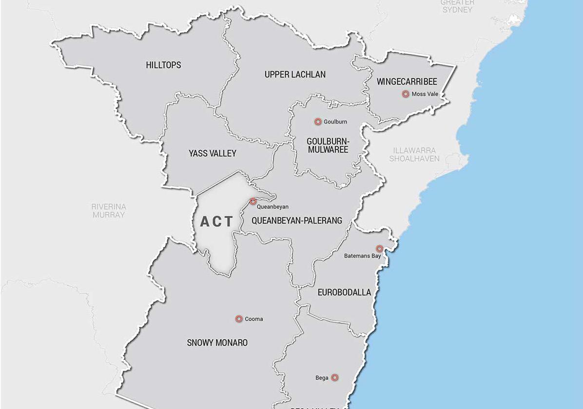
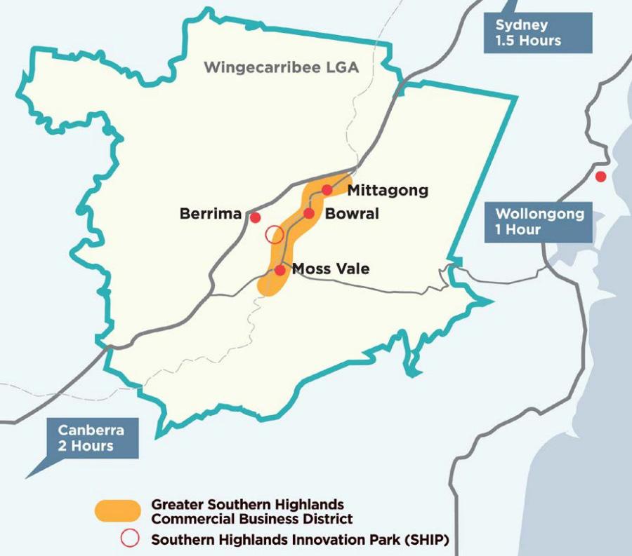
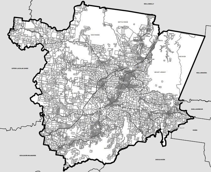
Moss Vale is located half way between Sydney and Canberra, in the Wingecarribee Shire Local Government Area (LGA) and is one of three towns that make up the Southern Highlands, alongside Mittagong and Bowral. Moss Vale is rich with colonial and diverse cultural heritage and recognises the Gundangara People as the traditional custodians of the land. Moss Vale has a land area of just under 80 square kilometres, with both major road and rail routes passing through the town. According to the 2021 Census, Moss Vale had an estimated resident population of 9,605 with a population density of 120.7 persons per square kilometre. The town has a unique country feel and is home to an array of gardens, vineyards and farmlands as well as several heritage listed landmarks.
In light of recent investigations into the construction of a fast rail line stretching from Melbourne to Brisbane, the opportunity to analyse and prepare a Strategic Precinct Plan and Urban Design Proposal for future development surrounding proposed line has been presented to students of the University of New South Wales. A potential station location in Moss Vale is proposed to service the Southern Highlands region and is the subject of this analytical proposal.
Methods of analysis that have been adopted to form an understanding of the character, opportunities and constraints development in Moss Vale include an assessment of current planning controls, an assessment of typography and geographical features, the identification of existing services, infrastructure and key places, a walkability analysis and an analysis of environmental constraints.
This analysis has informed the development of an opportunities map, highlighting areas in which future development could improve the liveability, vibrancy and sustainability of Moss Vale. In turn, opportunities mapping has inspired the formation of five, clear design principles to guide strategic planning processes and the proposed master plan.
The vision of this Urban Design Framework is to re-imagine the Moss Vale town centre complimentary of the existing heritage, infrastructure and open space. The vision also involves gently densifying the precinct and creating an active and accessible area safe for all. This framework will ultimately focus on two key blocks adjacent to the main street and Transport Hub, providing a master plan, domain structure plan, built form plan, 3D plans and yield plan as well as the proposed changes to LEP maps, crucial to the success of the proposed precinct plan.
1.2. Planning Context
South East and Tablelands Regional Plan 2036
The South East and Timberlands Regional Plan 2036 provides a framework for the NSW Governments in relation to land use planning priorities and decisions over the next 20 years. It relies on local councils to deliver the directions and actions set out in the plan and provides priorities for further investigation and implementation.
The Moss Vale locality is located within the Wingecarribee Local Government Area (LGA). Objectives for the future development of Wingecarribee under the Plan include the following:
• Protecting high environmental value lands and heritage assets as a priority for the LGA.
• Capitalise on the Moss Vale Enterprise Corridor to attract industry and investment.
• Increase the supply and diversity of housing options.
• Promote the Shire as a destination for visitors.
• Provide overarching planning principles for neighbourhoods, this includes:
• Public transport networks that link frequent buses into the rail systems;
• Streets and suburbs planned in a manner that supports residents walking to shops; and
• Easy access to major town centres comprising of a mix of shops, recreational facilities and services.
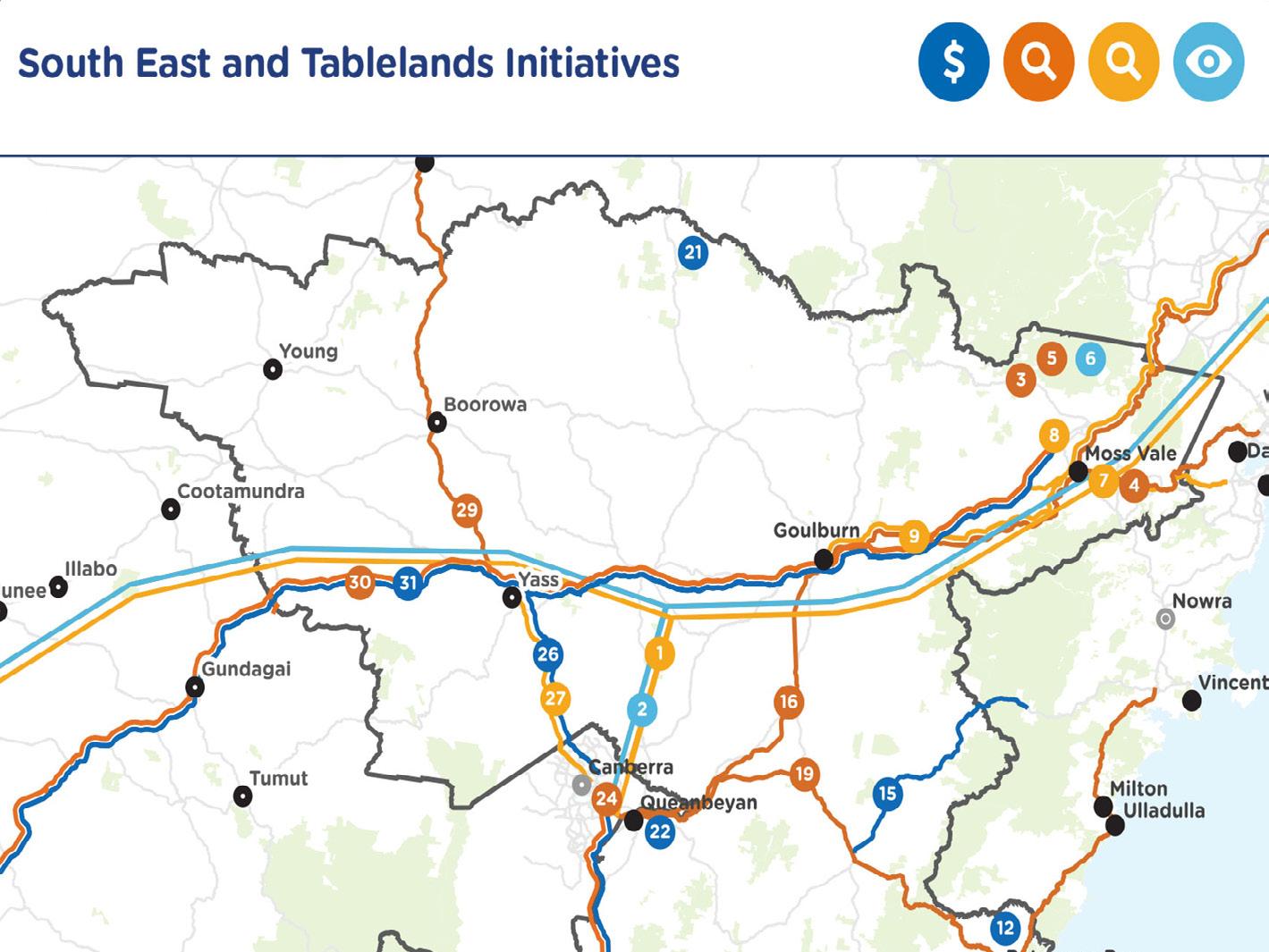
Regional NSW Services and Infrastructure Plan - Future Transport
The Future Transport 2056 Strategy is a state-wide strategic document which aims to guide the direction of transport planning in NSW to best support economic growth in the cities and regions.
The Strategy outlines a ‘vision’ for the states’ transport network, which is supported by key outcomes for governments to adopt, supporting aligned decision making.
In summary, the Strategy:
• Identifies improved connections between Canberra, Queanbeyan, Moss Vale, Goulburn, Batemans Bay, Cooma and Bega via improvements to existing connection or new services and connections.
• Improvements to existing connections include:
• Moss Vale to Unanderra rail connection;
• Local bus services; and
• Walking and cycling.
• Recognises that High Speed Rail should be investigated over the next 10 to 20 years.
Wingecarribee Local Strategic Planning Statement (LSPS) 2040
The Wingecarribee LSPS sets out a 20-year land-use vision within the shire and provides a long-term planning framework to meet the housing, social and environmental needs of the community.
The Wingecarribee LSPS provides further, detailed strategic planning guidance for the Moss Vale locality to achieve this vision. Key highlights of the LSPS include the following:
• ‘Moss Vale has undergone a transition to an increase of boutique retail and food and beverage offerings contributing to the revitalisation of the town centre that has supported it become a popular destination for visitors’.
• ‘A bypass route has been identified to revive Argyle Street from traffic pressure and remove heavy vehicles from the retail core and unlock the potential for the Moss Vale Enterprise Zone’.
• Moss Vale contains a generous supply of R3 Medium Density land currently consisting of old housing stock which could provide the opportunity for redevelopment within walking distance to shops, services and the railway station.
• The following have been identified as opportunities for improvement:
• Increased pedestrian priority in the town centre;
• Revitalisation of the town centre; and
• Well-designed residential release areas and Infill Development.
1.2. Planning Context
Southern Highlands Destination Strategy 2020-2030
The Destination Strategy aims to create an environment that is supportive of future local business and tourist-based economic development in the Shire. Key objectives of the Strategy include the following:
• Promoting the commercial corridor of Mittagong, Bowral and Moss Vale as the Greater Southern Highlands Commercial Business District is a priority.
• Ensuring that the planning framework facilitates new and innovative business opportunities.
• Establishing an education precinct at the Moss Vale TAFE Campus is being explored to deliver local training opportunities.
• The Moss Vale Enterprise Corridor is seen as a key economic strength of the Southern Highlands and will support a strong, local employment network and a healthy local workforce.
Wingecarribee
Local Environmental
Plan (LEP) 2010
Local Environmental Plans guide decisions within the applicable LGAs through zoning and development controls. Moss Vale is subject to the provisions of the Wingecarribee LEP 2010.
• A summary of the key objectives of the LEP are as follows:
• To conserve and enhance, for current and future generations, the ecological integrity, environmental heritage and environmental significance of Wingecarribee;
• Maintain Wingecarribee’s original settlement pattern of towns and villages dispersed throughout a rural and native vegetation landscape;
• To encourage the efficient use and development of urban land;
• To provide opportunities for a range of new housing and housing choice in locations with access t services;
• To strengthen the viability of Wingecarribee’s business centres;
• Discouraging the establishment of incompatible uses in bush fire prone areas; and
• To protect and enhance waterways, riparian land and water quality in the drinking water catchments of Wingecarribee.
Moss Vale Township Development Control Plan (DCP) 2010
The Wingecarribee DCP 2010 provides detailed provisions to supplement the Wingecarribee LEP 2010. The Wingecarribee DCP is broken in to several parts relating to specific locations and land uses.
• The Moss Vale DCP contains key controls relating to biodiversity, water management, flood liable land, vegetation management, subdivision, development near road and rail corridors and a range of building controls.
• The Moss Vale DCP is also accompanied by site specific DCPs, these include the following:
• The Chealse Gardens Coomungie Precinct Plan applies to land located to the South East of Moss Vale adjoining the Moss Vale Golf Course. The area is identified as a location for future low density residential housing. The plan contains key development controls relating future transport connections, subdivision, street network and hierarchy, open space networks, pedestrian and cycleway networks, and a range of building controls.
• The Moss Vale Enterprise Corridor DCP relates to land towards the north east between Moss Vale and New Berrima. The area is envisaged to cater for conventional light and general industrial development to meet local and regional demands for industrial land.
1.2. Planning Context
LEP Land Zone Map
Land zoning is a key development control under the Wingecarribee LEP 2010 that regulates the nature and use of development.
Land adjacent to the existing train station is predominately zoned B2 Local Centre and B4 Mixed Use, reflecting the economic significance of the area as a commercial centre of Moss Vale. Land surrounding the town centre is predominantly zoned R3 Medium Density Residential and houses the majority of Moss Vale's residents as it is well supported by public transport.
LOCAL CONTEXT
The land north of the Moss Vale town centre supports the daily operation of the town and is predominantly zoned RU4 Primary Production Small Lots and IN1 General Industrial. A number of sprawling greenfield residential developments zoned R2 Low Density Residential are located on the outskirts of town.
LEP Floor Space Ratio Map
Floor Space Ratio (FSR) is a key control of the Wingecarribee LEP 2010 that controls the scale and density of development.
Given the semi-rural nature of the Wingecarribee LGA, FSR is a relatively underutilised development control. In Moss Vale, FSR controls only apply to the town centre.
The predominant FSR of the buildings of the town centre of Moss Vale is 0.7:1. Blocks and parcels of land in and surrounding the town centre are governed by FSR controls of 0.5:1, 0.9:1 and 1.5:1.
LOCAL CONTEXT
LEP Height of Buildings Map
Maximum building height controls are another key element of the Wingecarribe LEP 2010 that control the scale and density of development.
The predominant height restriction of buildings in the town centre of Moss Vale, to the north and south of the train station is 7.5 metres. Land to the east of the train station is restricted to a maximum building height of 8 metres or 10 metres. Land to the west of the train station has a maximum building height of 10m.
Pockets of land surrounding the town centre also have building height controls ranging between 5 and 12.5m.
The low building height controls in Moss Vale reflect the semi-rural character and heritage charm of the township.
0
1.2. Planning Context
Land Use Map
Land use in the Moss Vale township is dominated by detached residential dwellings which emanate from the commercial core in the centre of town. There is a small amount of semi-detached dwellings and a distinct lack of medium to high density residential development. Land surrounding the heavy rail corridor and to the north of the town centre is dominated by light industrial uses. Community and public uses include sports fields, educational facilities, a showground and public services buildings. Pockets of vacant land remain scattered around both the centre and outskirts of town.
LEP Heritage
Map
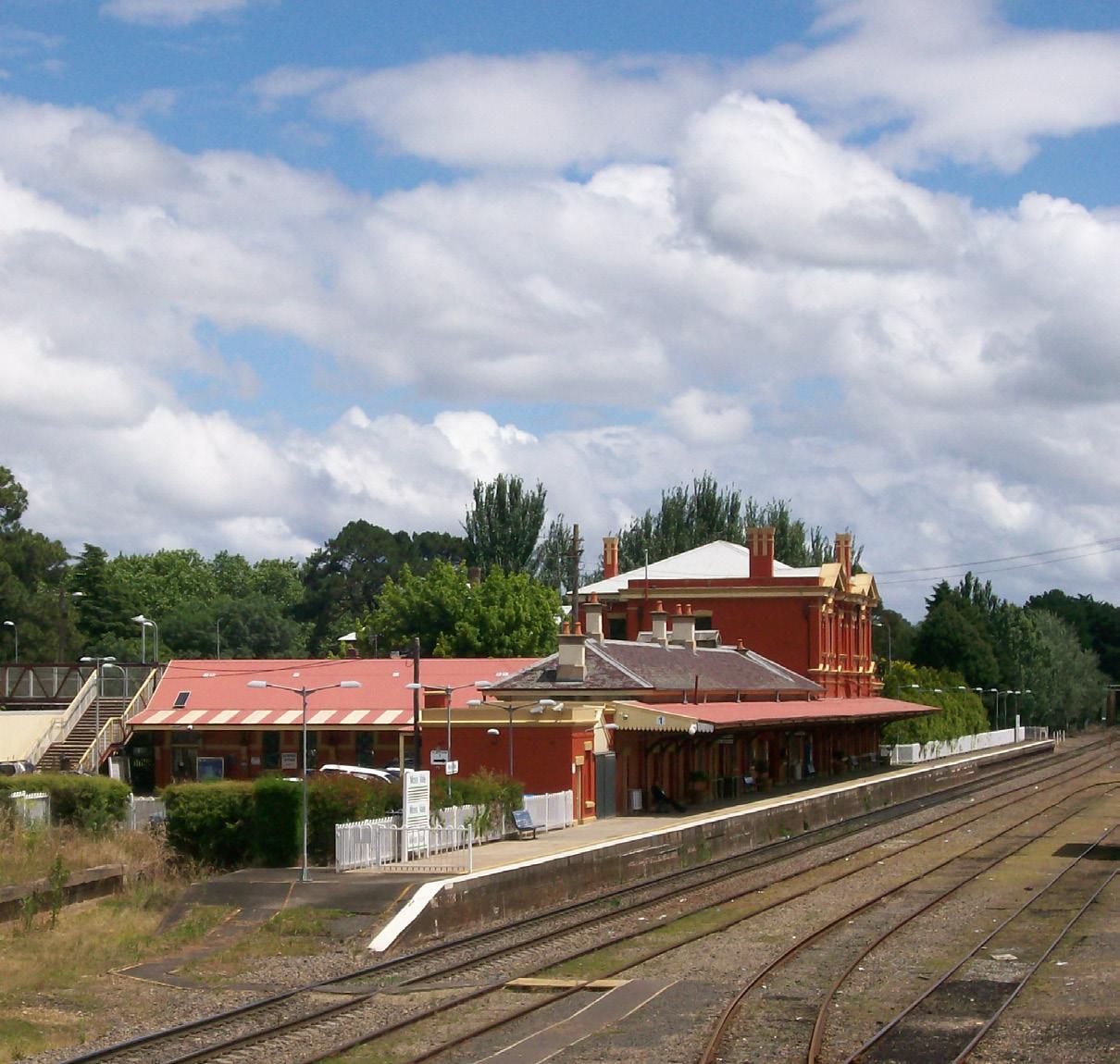
The township of Moss Vale was founded in 1861 and is home to a rich portfolio of colonial and Federation era heritage architecture. The township contains seven state listed heritage items, including the Railway Station, Rail underpass, Throsby Park and several colonial era estates such as Throsby Cottage, Park Barn on Church Road, ‘Oldbury’ House and grounds and ‘Whitley’ House and grounds. Moss Vale also contains three Heritage Conservation Areas of local significance which contain commercial, residential and public buildings and spaces characteristic of Federation era architecture.
Moss Vale is located on the lands of the Gundangara Nation and remains under the custodianship of the Gundangara people, however the landscape has been heavily modified by colonial settlers and there are no known sites of Aboriginal heritage significance located within the township or neighbouring lands.
CONSTRAINTS
LEP Sensitivity and Flood Planning Map
Land surrounding Whites Creek and comprising parkland and primarily residential development to the south of the town centre would be inundated during a 1 in 100 year flood event and is identified as Flood Prone Land.
The township itself is relatively unencumbered by environmental constraints. Conversely, land surrounding the town, particularly surrounding Whites Creek and other natural water bodies, is burdened by environmental corridors, natural habitat and water quality protection constraints.
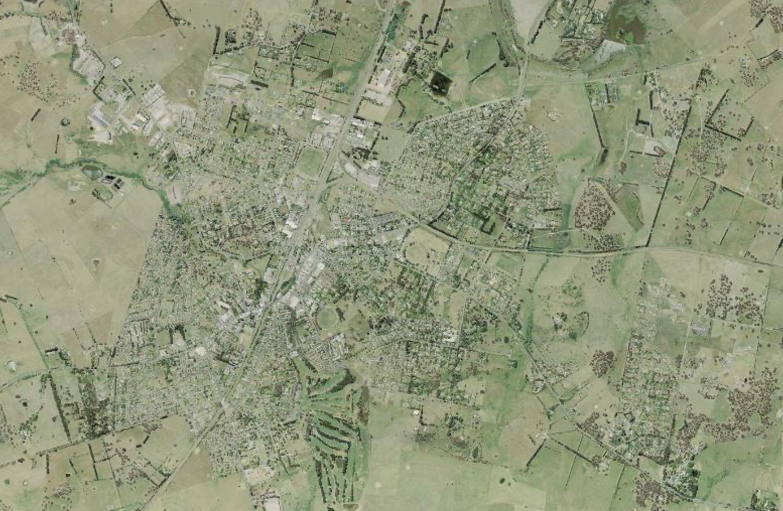
1.3. Urban Site Analysis
REGIONAL CONTEX T
1.3.1. Regional Context
REGIONAL CONTEX T
REGIONAL CONTEX T
Opening paragraph in bold
Opening paragraph in bold
Opening paragraph in bold
TOPOGRAPHY AND OPEN SPACE TYPES
fur ther key observations in dot point for mat
fur ther key observat ons in dot point for mat
The Moss Vale study area holds various open spaces, including local parks, playgrounds, private golf clubs, ovals, showgrounds, reserves and national parks. Being located in the highlands, Moss Vale is characterised by a vascillating typography of rolling country hills and mountainous escarpments.
• Moss Vale is approximately 700m above sea level and this elevation is shown by the thick contour lines.
• Moss Vale is surrounded by rural farm land with low, rolling hills. Steeper mountains are found within the town and near Morton National Park.
• Moss Vale is in close proximity to many rivers and creeks, including the iconic Wingecarribee River. Whites Creek runs through the centre of town. Other waterways include Bong Bong Reservoir, Kellys Creek, Schools Creek, Paynes Creek and Medway Rivulet.
• Morton National Park is found within the study area as well as three reserves, including Cecil Hoskins Nature Reserve, Mount Alexandra Reserve and Berrima Reserve.
• Within the study area, there are three private golf clubs, four sporting ovals and a Showground, which is used most notably for horse and greyhound races.
• A key historic landmark and public open space within Moss Vale is Throsby Park. This park is of national significance and is located towards the eastern extent of the Moss Vale township.
1.3. Urban Site Analysis
REGIONAL CONTEX T
1.3.1. Regional Context
Opening paragraph in bold
KEY CONNECTIVE STREETS
- fur ther key observations in dot point for mat
Moss Vale has direct and connective streets to many neighbouring regional towns. This map displays the primary and secondary structuring streets that run through Moss Vale.
• There are two primary roads that connect Moss Vale to other parts of the Southern Highlands, including the Illawarra Highway and Argyle Street. There are also three secondary or arterial roads; Moss Vale Road, Yarrawa Road and Berrima Road.
• Illawarra Highway is a two-lane highway connecting Moss Vale to Wollongong and linking the Hume Highway with the Princes Highway.
• Argyle Street is a busy, two-lane street moving through the Moss Vale town centre in both directions.
• Argyle Street links to Moss Vale Road which connects Moss Vale to Bowral.
• Yarrawa Road links to the Route B73; an important connection for the South Coast.
• Berrima Road is a two lane road moving in both directions linking to the Hume Highway and connecting Moss Vale to Berrima.
Secondar y Structur ng Streets
Secondar y Structur ing Streets
1:50,000
1.3. Urban Site Analysis
REGIONAL CONTEX T
1.3.1. Regional Context
Opening paragraph in bold - fur ther key observations in dot point for mat
KEY PUBLIC TRANSPORT ROUTES AND STATIONS
Moss Vale’s railway and bus routes help to connect the town to other key and neighbouring regional towns. However, stations and bus stops are sparsely located and are inaccessible to residents that do not reside in close proximity to the Moss Vale town centre.
• In the Southern Highlands, railway stations are sparsely located, with roughly one train station located in each town.
• The closest train station from the Moss Vale Railway Station is found 7km north-east in Burradoo. The Exeter Railway Station found 9km south-west of the Moss Vale Railway Station.
• There are ten key bus routes displayed on this map and these include routes 808, 811, 812, 813, SH100 and 751-755.
• These key bus routes travel to and from Moss Vale to other key regional points of interest such as Berrima, Bowral, Mittagong, Robertson, Goulburn, Wollongong, Bundanoon and other, smaller regional towns.
• The proposed High Speed Rail (HSR) station is located roughly 5km from the Moss Vale town centre. The HSR route curves makes an arc to the south and east of Moss Vale and intersects with existing passenger and heavy rail lines both southbound and eastbound.
• There are no existing bus routes that travel to the proposed HSR station, limiting accessibility. Currently, the closest bus stop is 2.5km away and the closest train station is 3.5km away.
1:50,000 @ A3
1.3. Urban Site Analysis
REGIONAL CONTEX T
REGIONAL CONTEX T
1.3.1. Regional Context
REGIONAL CONTEX T
Opening paragraph in bold
Opening paragraph in bold
SOCIAL INFRASTRUCTURE
There are eight special places within Moss Vale, including:
REGIONAL CONTEX T
Opening paragraph in bold
Bong Bong Common
Wingecarribee Shire Council Office
• There are many churches and retirement villages located within Moss Vale. There are also numerous cemeteries within the study area as well as two community centres and two sports clubs.
• With a relatively small population per square kilometre, Moss Vale has a generous amount of educational institutions. Moss Vale has four high schools, two primary schools and is also home to the TAFE NSW Southern Highlands Campus and the University of Wollongong Southern Highlands Campus.
REGIONAL CONTEX
• The Wingecarribee LGA Council Chambers are located at the centre of Moss Vale, adjacent to the Moss Vale Court House, Library, Civic Centre and the War Memorial Aquatic Centre.
• The closest hospital is the Bowral and District Hospital, located North East of the Moss Vale town centre, which is not visible at the scale of this study area.
y/High Schools
Spor ts Li brar
Special Places
Institutions/Uni versities
Prim ar y/High Schools
1.3. Urban Site Analysis
1.3.2. Local Context - Walkability
KEY AND UNIQUE PLACES
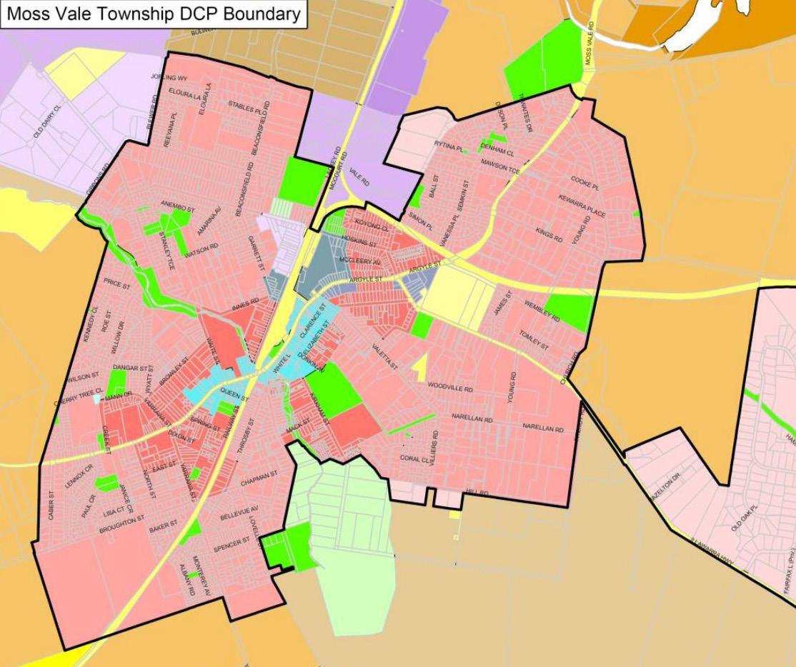
The town centre of Moss Vale is the key point of interest for the locality.
• As shown in the map, the town centre comprises a mix of commercial uses and is in close proximity to a number of community uses, including a court house, churches, a meals on wheels hub, council offices, memorial halls, and the like.
• As indicated in the 100m walking radius, walkability is achieved within the town centre. As you progress away from the town centre, educational establishments and key places such as the Corbett Walkway, showgrounds and some parks to the north achieve a level of connectivity but are restricted to areas in proximity.
• Furthermore, walkability to key places in the locality is dependent on, and impeded by, the length of block sizes and dead ends streets to the north. As such, movement to key places in the locality is restricted and the township is not considered to be highly walkable.
LOC AL CONTEXT - Walkabili ty to Key and U niq ue Places
1.3. Urban Site Analysis
1.3.2. Local Context - Walkability
LOCAL BUS ROUTES AND STOPS
REGIONAL CONTEX T
As shown in the map, a greater level of walkability is achieved within proximity to the local town centre.
Opening paragraph in bold
Surrounding development tends to represent a majority of residential and industrial land uses which are not appropriately serviced by public transport infrastructure or are characterised by subdivision patterns that do not support a walkable environment.
al
LOC AL CONTEXT - Walkabili ty to Key and U niq ue Places
Showground
1.3. Urban Site Analysis
LOC AL CONTEXT
LOC AL CONTEXT
1.3.2. Local Context - Environmental
LOC AL CONTEXT
Opening paragraph in bold
Opening paragraph in
Elements
TOPOGRAPHY, OPEN SPACE AND EXISTING WATERWAYS
Opening paragraph in bold - fur ther key observations in dot point for mat
fur ther key observations n dot point for mat
point for mat
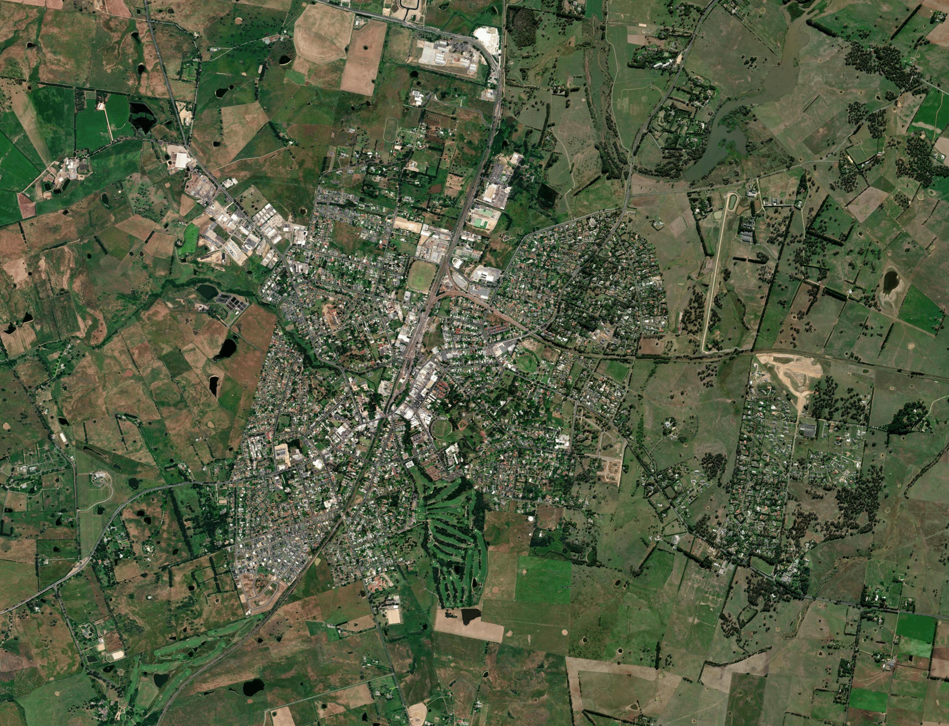
As Moss Vale is situated in the Southern Highlands, which is a mountainous region, it has a higher topography relative to coastal towns. Overall, the northern part of Moss Vale is lower in elevation, while the southern part is higher. Moss Vale is scattered with exisiting waterways running through and surrounding the town.
• The elevations in Moss Vale range between 668m AHD and 750m AHD. The topography of the city center is relatively level at an average elevation of 668 metres above sea level, while topography outside the city centre is, on average, 695 meters above seal level.
• Whites Creek is a natural waterbody that traverses the Moss Vale township to the south of Leighton Gardens. Numerous natural and man-made ponds, dams and lakes are scattered across the township for recreational purposes and to support local agriculture.
• Parks and open spaces are generally located in the outskirts of the Moss Vale town centre, mostly within residential areas, or along the Whites Creek. Among the parks and open spaces in Moss Vale, the most significant are Bevan Badgery Park, Moss Vale Showground and Lackey Park.
1.3. Urban Site Analysis
LOC AL CONTEXT
Opening paragraph in bold -
Opening paragraph in bold - fur
LOC AL CONTEXT
LOC AL CONTEXT
Opening
LOC AL CONTEXT
LOC AL CONTEXT
1.3.2. Local Context - Environmental Elements
Opening
Opening
Opening
KEY PUBLIC BUILDINGS AND STREET-BASED RETAIL
LOC AL CONTEXT
The town centre is centrally formed by the buildings and active frontages along Kirkham Street, Clarence Street and Argyle Street. Various types of services are available near the town centre including public facilities (library, civic centre, council, and court house), recreational facilities (sports and leisure facilities) and social services (vet hospitals, clinics, and aged care).
• The Moss Vale Public Library, Wingecarribee Shire Council, Civic Centre Theatrette, Community Oval and multiple churches are all located in the town centre.
• There is no hospital that could provide emergency service in or near the town centre, jowever there is a General Practice located on teh outskirts of town.
• The town centre and retail streets of Moss Vale are located along Argyle Street, Clarence Street, and Kirkham Street.
Opportunities Mapping
Design Principles
2.1. Opportunities Mapping
Existing Zoning
2.1.1. Moss Vale Opportunities
Not show ng public buildi ngs, special p aces or school s
Proposed Express Bus Route
Proposed
Using the findings gathered from an in depth analysis of Moss Vale’s planning context and a site analysis of Moss Vale at both a local and regional context, physical opportunities for uplift in the study area become present. The isolated location of the proposed High Speed Rail (HSR) presents an opportunity for Moss Vale to improve the existing transport interchanges and bus routes for better accessibility and a less car-dependent population. Further opportunities arise from the unique context of Moss Vale, which lends itself to densifying the town centre to more mixed-use development, as well as introducing high amenity open space and new access points for pedestrians and cyclists. This opportunities map identifies potential and specific opportunities for Moss Vale, including:
Proposed Express Bus Route
Proposed Express Bus Route
Proposed Express Bus Route
Proposed Express Bus Route
Proposed Express Bus Station
Proposed Express Bus Station
Proposed Express Bus Station
Proposed Express Bus Stat on
Proposed Express Bus Station
Proposed Express Bus Station
Proposed Transpor t Hub
Proposed Transpor t Hub
Spi ne
Proposed Transpor t Hub
Proposed Transpor t Hub
Proposed Transpor t Hub
Proposed Transpor t Hub
Proposed Express Bus Station
Proposed New Road
Spine Exisiting Parks
Connect the Moss Vale town centre to the HSR station with an express bus route that runs parallel to the southern railway route
Proposed New Road
Proposed New Road
Proposed New Road
Proposed New Road
Proposed New Road
Proposed Transpor t Hub
Spi ne
Proposed Wayward Gr id
Proposed New Road
Proposed Wayward Gr id
Improve the transport interchange between the railway station and the proposed express bus stop through an adaptive reuse of the existing railway station and underpass
Proposed Wayward Gr id
Proposed Wayward Gr id
Proposed Wayward Gr id
Active Laneway Frontages
Laneway Frontages
Spine Exisiting Parks Exisiting Parks
Spine Exisiting Parks
Introduce a new street that runs parallel to the southern railway route for bus and car travel from Moss Vale to the HSR station
Active Laneway Frontages
Street Frontages
Active Laneway Frontages
Active Laneway Frontages
Active Laneway Frontages
Active Laneway Frontages
Proposed Express Bus Route
Active Laneway Frontages
Proposed Wayward Gr id
Active Street Frontages
Active Street Frontages
Spine Exisiting Parks
Improve walkability in the Moss Vale town centre by defining a wayward grid structure with a maximum walking distance of 200m between each intersection
Active Street Frontages
Active Street Frontages
Active Street Frontages
Active Street Frontages
Proposed New Road Active Laneway Frontages
Proposed Green Spaces
Proposed New Road Act ve Laneway Frontages
Proposed Shared Pedestr an Zone
Proposed Express Bus Route
Proposed Shared Pedestr an Zone
Proposed Rezon ng
Proposed Shared Pedestrian Zone
Proposed Shared Pedestr an Zone
Proposed Shared Pedestr an Zone
Proposed Shared Pedestr an Zone
Proposed Green Spaces
Proposed Rezoni ng
Act ve Street Frontages
Proposed Rezoni ng
Proposed Rezoni ng
Proposed Rezoni ng
Proposed Rezoni ng
Exisiting Parks
Spine
Rezoni ng
Proposed Express Bus Station
Proposed Rezoni ng
Proposed Rezoni ng
Active Street Frontages
Blue- Green Cor ridor Proposed Wayward Gr
Shared Pedestrian Zone
Activate street and laneway frontages in the Moss Vale town centre with active food and retail uses to encourage pedestrian activity and security
Transform Clarence Street into a shared pedestrian zone and slow street with ground floor activation and high public amenity
Spine x Legend
Proposed Shared Pedestrian Zone
Densify and rezone the Moss Vale town centre to medium density, mixed-use developments to create a functionally integrated village style space with public and residential uses
Proposed Shared Pedestrian Zone
Proposed Transpor t Hub Study Area
Proposed Blue- Green Cor ridor
Green Spaces
Proposed Blue- Green Cor ridor
Proposed Blue- Green Cor ridor
Proposed Shared Pedestrian Zone
Incorporate a natural ecosystem that runs through the Moss Vale town centre by strengthening the presence of Whites Creek as a riparian corridor
Proposed Transpor t Hub
Proposed Green Spaces
Proposed HSR Route
Proposed Blue- Green Cor ridor
Proposed Blue- Green Cor ridor
Proposed Rezoni ng Act ve Street Frontages
Proposed Blue- Green Cor ridor
1:2500 @ A3 N B2 Loca Centre Legend
Introduce new and harness existing green spaces with playgrounds, park benches,
Proposed Green Spaces
Study Area
Proposed Rezoni ng
Proposed Green Spaces
Proposed Green Spaces
Proposed Green Spaces
Proposed Green Spaces
Proposed Green Spaces
Proposed HSR Route
Active Street Frontages
equipment and other high amenity uses
Proposed Blue- Green Cor ridor
Proposed HSR Station
Study Area
Proposed Shared Pedestrian Zone
Study Area
Ex sting Rail way Route Ex sting Rail way Station Study Area Proposed HSR Route
Proposed Transpor t Hub
Existing Rail way Route
Study Area
Proposed Green Spaces
Study Area
Whites Creek
Proposed Wayward Gr id Exisiting Parks
Existing Rail way Stat on
Parks
Proposed HSR Route
Creek
Exisiting Parks
Proposed Express Bus Station N
Proposed HSR Route
Proposed HSR Route
Proposed HSR Route
Existing Rail way Route
Creek Proposed HSR Station
Proposed HSR Station
Exist ng Ra l way Route
Existing Rail way Stat on
Creek Proposed HSR Station Exist ng Ra l way Route
Exist ng Ra l way Route
Exist ng Ra l way Station
Exist ng Ra l way Station
Exist ng Ra l way Station
N Exisiting Parks
2.1. Opportunities Mapping
OPPORTU NITIES
Proposed Express Bus Route
Proposed Express Bus Station
OPPORTU NITIES
2.1.2. Design Principles
Opening paragraph in bold
Proposed Express Bus Route
Proposed Transpor t Hub
- fur ther key observations in dot point for mat
There are five key design principles that will guide plans for Moss Vale, including:
Opening paragraph in bold
Proposed Express Bus Station
Improve Transport Interchanges and Access to High Speed Rail Station
Proposed Wayward Gr id
Define a Wayward Grid within the Town Centre
Proposed Transpor t Hub
Proposed New Road Active Laneway Frontages
Activate Street and Laneway Frontages
Proposed New Road
Act ve Street Frontages
Street Frontages
Densify the Town Centre and Create a Shared Pedestrian Zone
Proposed Wayward Gr d
Proposed Shared Pedestrian Zone
Strengthen the Presence of a Blue-Green Corridor Along Whites Creek
Proposed Wayward Gr d
Active Laneway Frontages
Active Street Frontages
Proposed Rezoni ng
Proposed Shared Pedestrian Zone
Proposed Blue- Green Cor ridor
Proposed Rezoni ng
Proposed Shared Pedestrian Zone
Proposed Green Spaces
Proposed Rezoni ng
Proposed Blue-Green Corridor
Proposed Green Spaces
Proposed Blue- Green Cor ridor
Proposed Green Spaces
Study Area
Proposed
Blue Spi ne Green Sp ne
Existing Ra l way Route
Existing Ra l way Station
Exisiting Parks Whites Creek
Proposed HSR Route
Proposed Transpor t Hub
Proposed HSR Stat on
Exisiting Parks N
Existing Rail way Route
Existing Rail way Station
2.2. Design Principles
OPPORTUNITIES
1. Improve Transport Interchanges and Access to High Speed Rail Station
Moss Vale is a heavily car-dependent population and with the introduction of the proposed HSR there is an opportunity to improve Moss Vale’s existing public transport with an express bus route that travels straight from the Moss Vale railway station to the HSR station along a new street.
The proposed HSR station is located in the middle of rural land, between Exeter and Moss Vale, along the existing railway. A sustainable solution to connect Moss Vale to the HSR station, with minimal impact on the surrounding fertile rural farmland, would be to introduce a direct street that runs parallel and as close to the southern railway route as possible. This new street is key to the proposed express bus route to the HSR station. Due to the existing railway station being heritage listed, an adaptive reuse of the existing station will allow the station to uphold its historical significance whilst providing additional amenities, such as an improved transport interchange between the railway station and the proposed express bus stop and a safe, accessible, pedestrian-friendly underpass.
OPPORTUNITIES
2. Define a Wayward Grid within the Town Centre 3. Activate Street and Laneway Frontages
Moss Vale has a poor grid structure that limits the walkability and pedestrianisation of the town centre. A defined wayward grid, with a maximum walking distance of 200m between each intersection, would improve walkability to and within the town centre and support the objective of the South East and Tablelands Regional Plan 2036 (Regional Plan) for ‘easy access to town centres’.
The thin purple arrows show existing and potential streets, lanes and walkways that lead directly to Argyle Street, which is the main street that runs through Moss Vale. Increasing the number of access points to Argyle Street and the town centre, supports a walkable and accessible street grid.
The thick purple line follows the organic shape of Argyle Street. It shows how a number of back streets already run parrallel to this organic shape and continuing this line along the length of the town centre would support a wayward grid structure. It also presents as an alternative back route to take the traffic pressure off of Argyle Street.
Moss Vale offers an exisiting retail and food culture that can be expanded further through active street and laneway frontages in the Moss Vale town centre.
The orange lines indicate potential active street frontages and the red lines indicate existing and proposed laneway access to the town centre.
The Wingecarribee Local Strategic Planning Statement (LSPS) 2040 recognises Moss Vale’s need to revitalise and prioritise pedestrians within the town centre, which can be achieved through active street and laneway frontages. Introducing ground floor activation through more active food uses and retail shop fronts, encourages security and pedestrianisation within the town centre.
2.2. Design Principles
OPPORTUNITIES
4. Densify the Town Centre and Create a Shared Pedestrian Zone
Moss Vale’s town centre is mostly dominated by local centre land uses as well as medium density residential and a small number of business and mixed-use developments with no high amenity pedestrian spaces.
Clarence Street, sits parallel to Argyle Street and the railway station and is an optimal location for a shared pedestrian zone and slow street with ground floor activation and high public amenity. Along Clarence Street there are numerous car parks, three of which could be used for alternative active uses such as wider pedestrian paths or public buildings.
The Wingecarribee LSPS 2040, the Wingecarribee LEP 2010 and the Regional Plan 2036 all share a common objective for an increase in housing supply and diversity in proximity to shops, services and the railway station. Moss Vale can achieve this by gently densifying the town centre through rezoning the area to mixed-use development. Medium density, mixed-use developments, such, as shop-top housing, would support a functionally integrated village space with public and residential uses.
5. Strengthen the Presence of a BlueGreen Corridor Along Whites Creek
W hites Creek is an existing waterway surrounded by riparian land that runs through Moss Vale. Strengthening the presence of this blue-green corridor through the town centre will support human health and encourage interaction with green open space.
Whites Creek lends itself to becoming a natural ecosystem and riparian corridor through the town centre. A strong presence of a blue-green corridor along Whites Creek would support the Wingecarribee LEP 2010 objective, ‘to protect and enhance waterways and riparian land’. Improving the corridor could also reduce flooding along Whites Creek by acting as a sponge to drain and soak up heavy rain.
The green circle buffers highlight existing green spaces that could be activated with walkways, playgrounds, park benches, gym equipment and other high amenity uses.
2.2.1. Exemplar Designs
OPPORTUNITIES
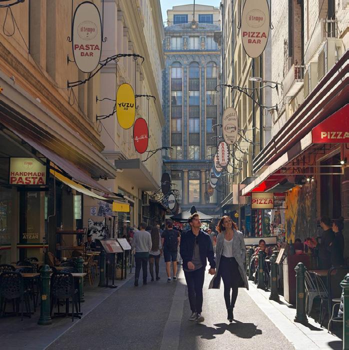
frontages along Degraves Street, Melbourne (Photograph by Mariot 2022)
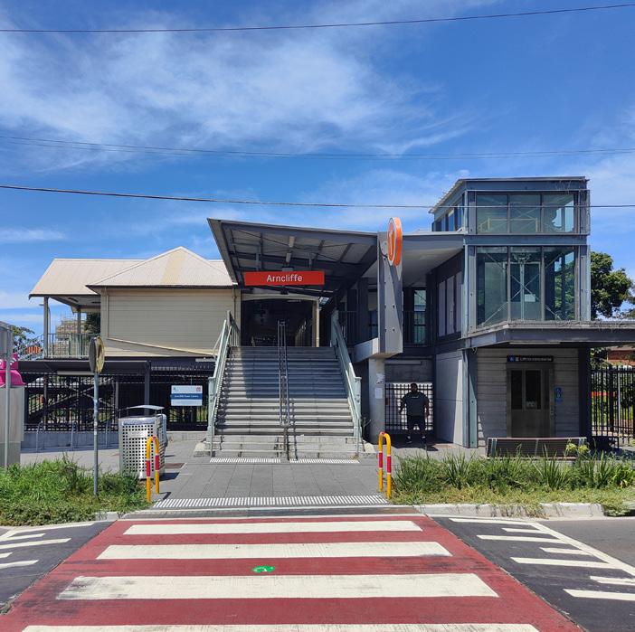
Adaptive reuse of railway station in Arncliff, NSW (Photograph by Jim Bar 2021)
Shared zone along Marunouchi Naka Street, Tokyo (Photograph by Tripadvisor 2022)
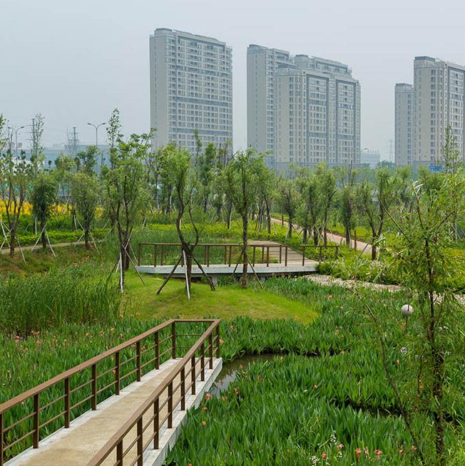
Blue-green eco-corridor in Ningbo, China (Photograph by SWA Group 2021)
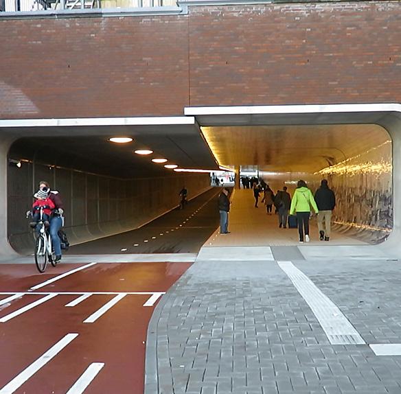
Pedestrian and cyclist underpass in Amsterdam, Netherlands (Photograph by Ruan Scott 2016)
STRATEGIC PRECINCT PLAN
3.1. Precinct Location
3.1.1. Precinct Location
The proposed precinct is located at the centre of Moss Vale and includes the Moss Vale Town Centre, the existing Railway Station, and Whites Creek.
• The proposed High Speed Rail (HSR) station is located roughly 5km from the proposed precinct location. The HSR route curves makes an arc to the south and east of Moss Vale and intersects with existing passenger and heavy rail lines both southbound and eastbound.
• All three precinct layout options, as well as the preferred precinct plan are located here, as outlined by the site boundary.
• Each precinct layout option will be analysed against the defined Design Principles from Chapter 2 and the strategic directions as well as their physical opportunities and misgivings. This analysis will then guide the design of the preferred precinct plan, which will appropriately incorporate the most admirable qualities of each option into one precinct plan.
3.1.2. Exemplar Designs
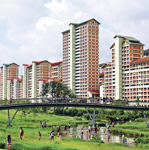
design and activation in Bishan-Ang Mo Kio Park, Singapore (Photograph by Ramboll Studio Dreiseitl 2016)
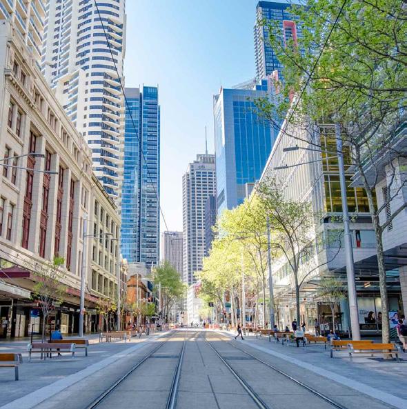
pedestrian zone along George Street, Sydney (Photograph by Ben Hansen 2021)
2.2. Precinct Plan Options
OPPORTU NITIES
Option 3
3.2.1. Option 1 - Pedestrian Orientated Plaza Precinct
OPPORTU NITIES
Option 1 proposes a well-structured street grid and introduces safe pedestrian infrastructure throughout the Town Centre. This option defines a clear wayward grid with straight and direct routes to the main street. Ground floor activation becomes attainable through the proposed public buildings and recreational potential. Shared pedestrian zones are proposed along three local streets encouraging safe pedestrian engagement with the Town Centre.
OPPORTUNITIES :
Proposed open spaces and parkland connect to the existing Bevan Badgery Oval, creating an extensive green corridor through the Town Centre. These open spaces also interface with the proposed High/Primary School.
Using a combination of the existing and proposed streets, the almost parallel local streets and laneways now follow the shape of the main street.
The existing pocket parks to the very right and very left of the study area are now directly connected via proposed laneways, local streets and shared pedestrian plaza.
The large pedestrian shared plaza space creates a pedestrian orientated local square, extending the Town Centre and better connecting the Town Centre to the Railway Station and the existing University and TAFE.
Additional community and cultural buildings within the Town Centre are easily accessible and encourage pedestrian use.
Well-structured wayward street grid, through straightening existing streets and introducing proposed street and laneways that run parallel to each other.
MISGIVINGS
OPPORTU NITIES
The proposed grid structure involves directly cutting through the existing street grid, substantially disrupting the existing built environment and character of the town.
The proposed blocks are walkable with mid-block laneways but they are not completely pedestrian orientated, with a majority of block lengths reaching close to 200m.
2.2. Precinct Plan Options
OPPORTU NITIES
3.2.2. Option 2 - Natural Environment Activation
1
OPPORTU NITIES
OPPORTU NITIES
Opening paragraph in bold
observations
blue-green corridor along Whites Creek.
Introduction of Civic Plaza Park located on the existing Bevan Badgery Oval, will encourage pedestrian interaction with local parks and open space.
With the proposed densification of Moss Vale, tree-lined streets and laneways help to reduce urban heat-island effects and connect pedestrians to the natural elements that characterise Moss Vale today.
The proposed open space along Argyle Street creates a green interface with the main street, enhancing the presence of Whites Creek.
Existing Librar y
All proposed streets and laneways, integrate well with the existing street grid and connect to existing local streets.
Librar y Existing Aquati c Centre
Extension of the existing Community Civic Centre across the street to create a Community Cultural Centre encouraging pedestrian use of community buildings in the Town Centre.
Proposed Health Hub Existing Community Centre
Proposed Communi ty Centre
The proposed Civic Plaza Park will disrupt the existing Bevan Badgery Oval and this open space should be accounted for as this layout option does not propose enough significant open space.
OPPORTU NITIES
The location of the proposed High School means that it doesn’t interface with any community or recreational uses.
The cul-de-sacs in the South-East of the precinct plan obstruct walkability and should be better connected through laneways.
2.2. Precinct Plan Options
OPPORTU NITIES
3.2.3. Option 3 - Highly Connected Wayward Grid
OPPORTU NITIES
OPPORTU NITIES
Enhanced walkability and civic engagement with block lengths of less than 100. This is achieved through the introduction of proposed streets and laneways for pedestrian and cyclist use.
Location of proposed High/Primary School combination is found adjacent from the proposed Community Centre allowing students to interact with the public building.
For the most part, proposed streets and laneways follow the existing grid structure, minimising disruption to the Town Centre.
The layout option proposes significant open space along Whites Creek enhancing the presence of a blue-green corridor through the Town Centre.
Proposed Lanew ay
Librar y
Extension of the existing laneway that is located to the right of the existing Bevan Badgery Oval all the way to the centre of the proposed Plaza better connects the Town Centre to the existing University and TAFE.
The located of the proposed Community Centre is too far from Town Centre discouraging public use, it is recommended that a second Community Centre is proposed within the Town Centre.
OPPORTU NITIES
This layout option is not completely pedestrian orientated with only one shared pedestrian zone along Clarence Street.
2.3. Preferred Precinct Plan
OPPORTU NITIES
STREET
ILLAWARRA HIGHWAY
3.3.1. Preferred Urban Layout Option - Hybrid
Opening paragraph in bold
Preferred Option
fur ther key observations in dot point for mat
Using the findings gathered from a critical evaluation of the physical opportunities and misgivings of each layout option, it becomes easier to see what should be present in the preferred layout option. This preferred urban layout is hybrid of all three layout options, combining all of the most admirable qualities of each, such as, the location of public buildings, plazas, open spaces, streets, and laneways. The stronger options had walkable blocks, accessibility to public buildings and recreational uses, ground floor activation, safe pedestrian infrastructure, and significant open space and parklands that interact with Whites Creek that runs through the Town Centre. The three layout options and the five Design Principles outlined in Chapter 2 guided the design of this Precinct Plan, as follows:
1. IMPROVE TRANSPORT INTERCHANGES AND ACCESS TO HIGH SPEED RAIL STATION: For this proposed precinct plan, access to the HSR involves access to the Transport Hub at the existing Railway Station. Therefore, the proposed extension of the laneway that runs through the middle of the Town Centre from Option 3 provides the best accessibility to the Railway Station from all buildings in proximity to this laneway.
2. DEFINE A WAYWARD GRID WITHIN THE TOWN CENTRE: The proposed street grid from Option 3 is the main influence for the grid structure in this precinct plan with some aspects from Option 2, such as, the straightening of Spring Street and the laneways across Whites Creek. This wayward grid structure towards the main street proposes minimal disruption to the existing street grid.
3. ACTIVE STREET AND LANEWAY FRONTAGES: The proposed mixed-use and non-residential development densities will all provide ground floor activation through retail, food and business options. Activation in the Town Centre will also be attainable through public buildings including the location of the two proposed Community Cultural Centres influenced by Option 2 and 3 and the proposed health hub and library from Option 3.
4. DENSIFY THE TOWN CENTRE AND CREATE A SHARED PEDESTRIAN ZONE: The shared pedestrian zone in this precinct plan is a combination of all three plaza options to create a significantly pedestrian orientated Town Centre. The precinct plan is proposing gentle densification across the Town Centre to medium density mixed use development with surrounding low density mixed use development. This will look like shop top housing with ground floor food and retail options and will involve the adaptive reuse of heritage conservation buildings present in the Town Centre. The proposed low density non-residential development will look like 1-storey developments with food, retail and business options and the medium density non-residential development will look like 2-storey developments with top floor business options.
Option
5. STRENGTHEN THE PRESENCE OF A BLUE-GREEN CORRIDOR ALONG WHITES CREEK: The open space and parklands in this precinct plan are an adaptation of Option 2 and 3 and enhances the presence of a bluegreen corridor with the majority of open space surrounding Whites Creek. The proposed civic plaza park will disrupt the existing Bevan Badgery Oval, but this will be accounted for outside of the study area, as there are already two other ovals seen to the right of this study area and to the left of the Railway Station.
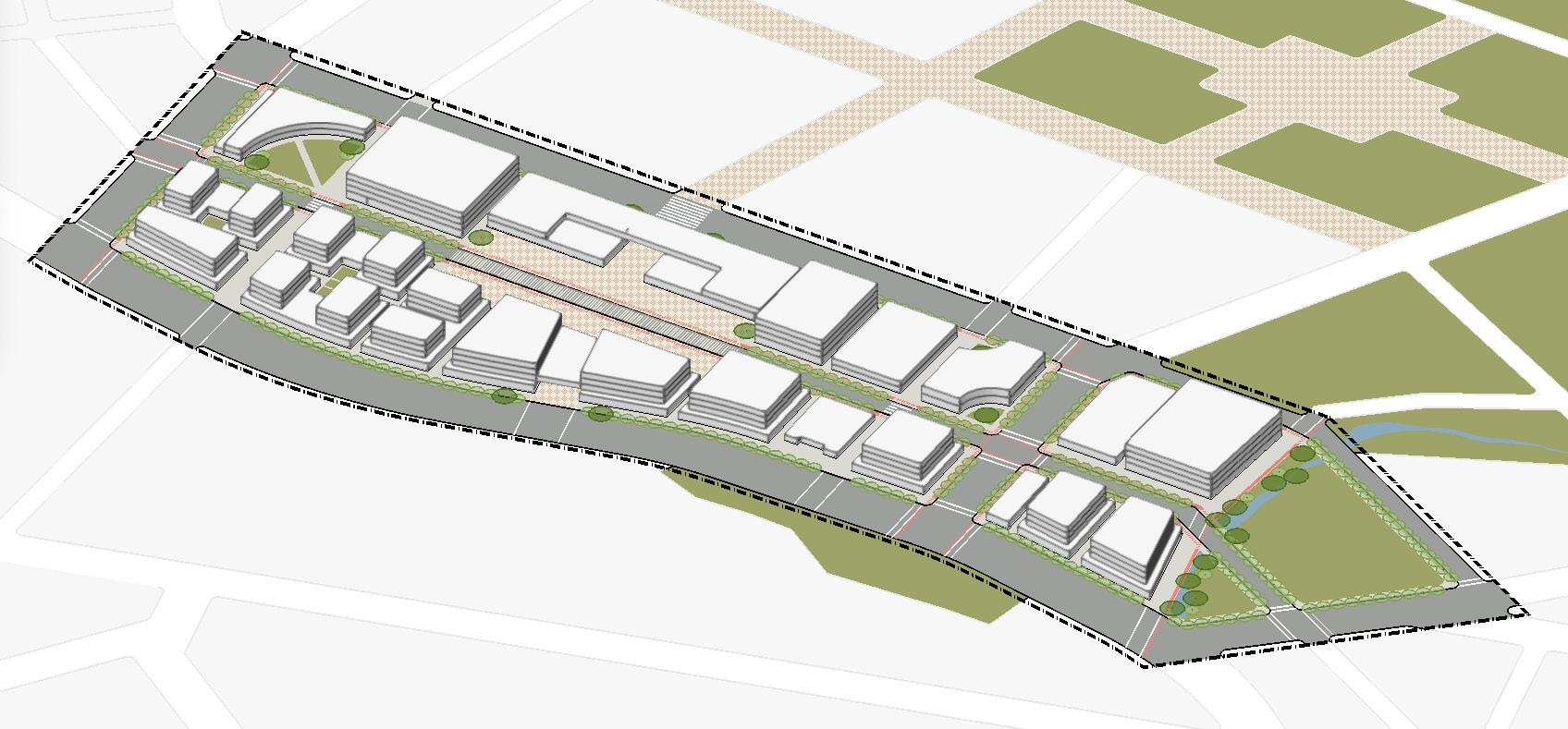
4.1. Illustrative Master Plan
Existing Zoning
4.1.1. Illustrative Master Plan
Illustrati
The illustrative master plan proposes a finer grain, detailed plan for two blocks adjacent to the main street and proposed Transport Hub. The precinct area responds to five design principles and is reimagined as a medium-density active town centre supported by the presence of Whites Creek, active transport, shared pedestrian zones, community buildings and rich heritage.
• Small native trees are use for the street planting that is found consistently along the edges of all roads and pathways in the precinct area to increase shade in key pedestrianised areas and for the car parking spots integrated along the green strip. Large landmark native trees can be found in the centre of the shared plaza and at the entrances for the library and community cultural centre.
• Whites Creek is located to the bottom left of the precinct and has a much larger presence in the area with clear pedestrian and cyclist routes and direct access from Argyle Street, Clarence Street and Throsby Street.
• Proposed public open spaces are found at the entrances for the library and community cultural centre. Internal courtyards are proposed for the mixed-use residential buildings found at the top of the precinct. To support a healthy environment in the precinct area rooftop gardens are proposed for two mixed-use residential buildings as well as the proposed health hub to minimise the effects of densification.
• A pedestrianised precinct with active transport is achieved through two-way bike paths that cover most of the precinct, as well as widening the curbs and pathways, introducing more street and zebra crossings, creating a shared pedestrian zone along Clarence Street and incorporating through site links throughout the whole precinct area.
4.2. Public Domain Structure Plan
Existing Zoning
4.2.1. Public Domain Structure Plan
Block and Bui lding Types
Public Dom ai n Structure
The Public Domain Structure Plan achieves the five design principles by locating the main street between the Transport Hub and the precinct area, by creating a clear grid through site connections to Argyle Street and Whites Creek, by densifying the precinct area and by providing active transport and ground floor activation.
• Argyle Street is the main street that runs through the precinct area and is located between the Transport Hub and the precinct. The location of the main street is intentional to not obstruct pedestrian movement within the precinct. Clarence Street is a pedestrian-orientated local street with a shared pedestrian zone and acts as the spine of the precinct area running directly through the middle.
• The precinct area successfully creates active streets through two-way bike paths and through site connections in and around the precinct. Bus routes move around the edges of the precinct area as not to obstruct the pedestrianised streets within the precinct area.
• All buildings within the precinct respond to the surrounding context and infrastructure of the precinct area and Moss Vale's broader town centre. Proposed buildings compliment the existing and proposed public open space and maintain the existing character of the shop frontages and heritage buildings along Argyle Street through appropriate setbacks of 3m for proposed residential storeys.
4.3. Blocks and Built Form Plan
Existing Zoning
4.3.1. Building Types and Dimensions
Block and Bui lding Types
There is a diverse range of building types proposed within the precinct area. Building types were chosen with the five design principles in mind as well as street frontage, orientation and proximity to open space and public transport. Pedestrian safety, permeability and accessibility was also key to the decisions made.
• For building types along the ground floor, the key design principle was active street and laneway frontages. Therefore, activation through retail, cafes, restaurants, community buildings, and supermarkets can be found on the precincts ground floor. Community buildings can be accessed easily along street frontages and include a library, health hub, court house, police station, and community cultural centre. There are two supermarkets already found in the precinct area and these are made much more accessible via active transport routes and street parking.
• In order to gently densify the town centre there are two mixed-use buildings and 14 mixed-use residential buildings proposed in proximity to the Transport Hub. These buildings also help to activate the centre and are either orientated towards the Transport Hub, Whites Creek or the shared pedestrian zone along Clarence Street. All residential buildings are in proximity to private or public open space for resident use.
• Buildings along Argyle Street are classified under a heritage conservation area. Therefore, building types were chosen to compliment the existing heritage buildings within the precinct, maintaining the existing uses, some with additional storeys above.
4.3. Blocks and Built Form Plan
4.3.2. Building Heights and Subdivisions
Block and Bui lding Types
The height of buildings within the precinct area range between 1-4 storeys to not disrupt the existing character of Moss Vale's town centre.
• Mixed-use residential buildings are the tallest buildings in the precinct area being a total of 4 storeys high which includes 3 storeys of residential developments above 1 storey mixed use developments.
• Community buildings such as, the library, health hub, court house, police station, and community cultural centre have a maximum of 2 storeys. This helps to distinguish these buildings from the residential mixed-use buildings.